Tuesday, October 1, 2013

It's been 2 years since our last NFCT trip and Team Krispy Treat decided to tackle sections 12 and 13.  We set off on our big adventure on Sept 19th leaving work at noon and driving to Bangor, Maine.  On Sept 20th we drove the rest of the way to the Allagash Wilderness Waterway.  We checked in at the North Maine Woods and paid our fees.  On the way out we noticed two guys checking out our boats.  Turns out he was the Allagash Wilderness Waterway director.  He asked where we were paddling and how long our trip was.  We told him we planned on starting at Chesuncook Lake to Umbazookus Stream and from there would head up through the mud pond carry.  He asked us why we would do such a stupid thing.  He mentioned how difficult the trail was and why anyone would want to even attempt it.  He said "You know you can cut that portion out of the trail and just put in at Chamberlain Lake which is only a 15 minute drive".  Nope we told him.  We have our heart set on tackling the Mud Pond Carry.  They both laughed and we went on our way.  Little did we know what lied ahead.

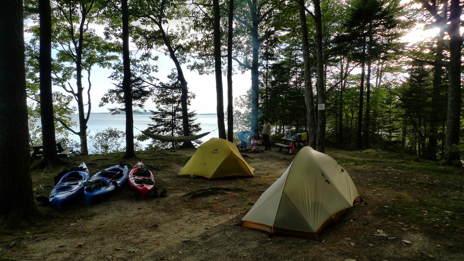
We arrived at the put in at the northern end of Chesuncook Lake.  It was a small parking lot near a very nice campsite.  Chesuncook Lake is a beautiful quiet lake.  The lake was calm, the weather was beautiful.  We couldn't wait to get our boats in the water.  We began our journey around 12:00pm.  We paddled about 1 mile to the end of Chesuncook Lake and then entered the Umbazookus stream.  Normally this stream is dried out but due to the amount of rain they had the week before it was flowing nicely.  We had to get out of our boats at a few spots that were low and line our boats through the water.  We reached the mouth of Umbazookus Lake and had to navigate our boats through a old out of commission dam.  Once on Umbazookus Lake we paddled across looking for the cairn that marked the entry to the mud pond carry.  Once we located the entry to the carry we assembled our gear and prepared ourselves for what lied ahead.  We had overheard from many that this carry was challenging and 2 miles through nothing but mud but nothing really prepared us for what we were about to encounter.
Team Krispy Treat....ready for our journey
Umbazookus Lake

How on earth will I get over that??????

The cairn marking the beginning of the mud pond carry

Jay and I had planned two ways to carry our boats.  First we planned on carrying them side by side with our gear loaded in our backpacks so we could attempt to do the carry in one straight shot.  No more than 200ft into the carry we decided this wasn't going to work out.  After falling a few times on the rocks we opted to ditch our gear and attempt to carry our kayaks on our shoulders.  While Jay was working with his boat and gear I worked on assembling the yokes that we had built for our kayaks.  With my kayak finally on my shoulders I set off with my hopes high of tackling this portage.  Not more than 50ft away the kayak started to slip and I started to lose it.  I picked up my boat off my shoulders and flung it into a tree.  I realize that was not the smartest move but my shoulders hurt so bad and I was mad.  Praise God that Wilderness Systems makes sturdy boats. :-)  With our boats and gear we sat and waited on Ed to arrive.

Ed had spent one weekend working on his kayak carry.  It was a ladder looking thing.  He strapped his kayak to the top of the ladder, hooked it on his shoulders and off he went.  As Jay and I sat waiting for Ed to arrive we wondered how his contraption was holding up.  Just a few minutes later Ed arrived with the news that his ladder kayak carry thing had split and would no longer hold his boat.  The mud pond carry was quickly becoming the carry from hell.
A small clip from the carry

We gathered together trying to decide what to do.  We still had over 1 mile to go and darkness was quickly approaching.  We decided that we would take turns carrying boats and when we got tired we would go back for our gear and would continue this until the end of the carry.  About 1/4 mile down the trail we reached a road.  This road looked strangely familiar.  Was it the road that we drove on to get from Chamberlain lake to the northern end of Chesuncook Lake?  We consulted our map.  Sure enough.....we huddled together again and decided that it would be easier for us to wheel the 5+ miles to Chamberlain Lake than to continue the mile mud pond carry.  With all our gear together and our wheels strapped on we headed toward Chamberlain.   On the map Jay noticed a stream that would connect us to Mud Pond (the actual pond and not the carry).  We decided to try that out.  Once we arrived at the stream we loaded up our gear into our boats and set off down this un-named stream.  We didn't make it far until we hit the first beaver dam.  Ed decided to make a run for it and launched himself over the dam with no problems.  By this time I was tired and I was afraid because it was cold outside.  I said a quick prayer and launched myself over the same dam.  Just around the corner was another dam.  Again we launched ourselves over.  Around the next corner was a huge blowdown.  I got out of my boat to see if we could carry our boats around the blowdown and continue on.  The stream was no where in site.  We paddled back up over the beaver dams and back to the road we started on.  Once again we didn't know what else to do.  We talked about going back to the car and driving it to Chamberlain Lake but darkness was quickly approaching.  Since Jay was the most fit person in our group we decided that he would run back to the car (4 miles away) pick it up and come back to pick us up.  We would continue to the lake.  We decided to do this because the outfitter was supposed to come and shuttle our car.  We didn't know if it would be there when we arrived back.  We figured Jay could run to the car.  If it was there he would get us, if not, we knew he would be able to make it back way before Ed and I could ever get there.

As Ed and I walked the road darkness was falling and I was getting more and more exhausted.  Ed kept encouraging me to push on my making fun of me to make me laugh.  At one point, while walking, I told Ed I couldn't go any further.  With my pack strapped to my back and my boat on the wheels I set the boat aside and I laid down in the middle of the road.  Ed kept telling me I needed to find somewhere else to lay but I was beat.  Finally I got up and pushed forward.  About a hour or so later I heard a car.  Could this be Jay?  Wow, he's quick.  Here come Jay down the road.  I was so relieved to see him.  He pulled up, rolled down his window and said "What's up, bitchezzz!".  I seriously thought I was going to fall over I was laughing so hard.  That was just what we needed.  We loaded up our boats and headed toward the North Maine Woods office so we could get in touch with our outfitter to let him know we had moved the car.  No cell service in this neck of the woods.  The ladies at the NMW office I'm sure was laughing at us.  They had just saw us 5 hours earlier when we told them our plan.  After talking with our outfitter we headed back to Chamberlain to speak with the ranger and ask if we could camp on his front lawn.  Instead he told us to move to the back of the parking lot to set up camp.  This is illegal in this area but he said as long as we had packed up and was out by dawn it would be OK.

That night the wind kicked up.  Chamberlain Lake is known for it's strong winds and ability to capsize small boats so I worried that once again we would not be able to get the mileage in we needed to complete the trip.  When we woke up the next morning we had a tough time rolling out of bed.  Every inch of our bodies was sore and I was bruised from the carry the day before.  The wind was still howling.  While in our tents we all discussed calling the trip.  This is something I really didn't want to do since it took so long for me to plan but we all felt we needed to call it.  We packed up our gear and once again headed toward the NMW office.  We got a hold of the outfitter and told him that we were not going to continue with our plans and that we wouldn't need his services anymore.  We checked out of the NMW/Allagash Wilderness Waterway and set off for Millinocket.  We planned on having breakfast at McDonalds so we could use the WiFi and look for a place to spend the next week.  We decided to head to Lubec, the easternmost point in the US and a 'lobstah' fishing town I have always wanted to visit.

Once we reached Lubec we headed for the Sunset Point RV park to check it out.  It was the only place to camp.  It was nice and quiet with only a few campers around.  We set up camp right near the ocean and under a shelter since it was supposed to rain the next day.  That night we headed to downtown Lubec to have lobster at the wharf.  The lobster was so good.  That night the wind kicked up again.  I had zipped up the vestibule on my side of the tent and the fabric was bending in and touching my side.  


Lubec Harbor

Our nice view

The next morning we headed to the West Quoddy Head Light since it hadn't started raining yet.  We spent a lot of time along the shore checking out rocks and watching the waves.  Afterwards we headed to Monica's Chocolates.  The guys wanted to pick up some since we heard her chocolate was amazing.  I picked up some white chocolate with caramel and peanuts.  By then it has started raining so we headed back to camp.  We sat in our tents reading for the rest of the day.


Ed is that really tea?????

The following morning Jay and I woke up really early to catch the sunrise at the lighthouse.  It was cloudy but still beautiful.  We then packed up the car and headed to Freeport.  We checked in at the Recompense Campground.  It is a large working farm with campsites available.  This campsite was nice overlooking the ocean again, however,  I would not recommend it to those looking for solitude during the peak travel season.  The campsites are right on top of one another.  For us though it was perfect because only one other couple had a tent in our area.


Campsite #2 in Freeport

So I told the guys the clams were spitting.  I had the best time watching them wait for the clams to spit.  HA HA

The Clam Master


That night we headed to the L.L. Bean flagship store.  That place is HUGE!!!!!  I picked up some running shoes because I want to attempt jogging again.  We had lobster again that night downtown.  The next day we headed to Top Gun of Maine to rent some guns and shoot at the indoor range.  That night we headed downtown again but this time we had pizza at a local place called Amato's. It was so good we would go there again before heading home.  When we returned back to camp I decided I wanted to kayak.  I went out into the bay just to sit and relax.  Next thing you know 2 seals popped up and started to stare at me.  They started coming closer and closer.  When I moved my paddle to paddle back some and they would flap their fins and dive.  They would swim to the back side of my boat and sit and watch me again.  That was SO COOL!


The following day was our last day in Maine.  We decided to kayak to South Freeport to have Lobster....again.  It was about a 5 mile kayak through Casco Bay.  Once we reached the harbor we floated through a ton of sailboats.  I personally enjoyed this as sailing is something I have always wanted to do.  We had lunch at Harraseeket Lunch and Lobster.


Parking the boats at the dock.  So fun.

The following day we headed home.  It was a great and relaxing trip.  Next year we plan on attempting the same NFCT section.  We hope you will join us :)

Tuesday, July 12, 2011

Section 2 - Union Falls Dam of Section 3

July 2nd - July 5th, 2011

Day 1:
View from our campsite at Lake Eaton Campground


Woke up way too early today as dawn creeps into our tent much easier than it does our bedroom at home with it's smallish windows and mini-blinds.  By 5:30 I was up and packing up my stuff.  Poor Louise isn't used to getting up so early but she was a trooper.  After packing up our gear we headed to the Long Lake Diner for breakfast.  We had a long day ahead of us and needed fuel.  I had a breakfast burrito with biscuts and gravy (weird, I know) and Jason had french toast, bacon, hashbrowns, scrambled eggs and coffee.  Anyone doing this section should really take the time to visit this diner.  Great service and good food.  By 7:30 we arrived at the Long Lake beach.  The outfitter, Raquette River Outfitters, has a small office/store across the street.  We began unloading and sorting all our gear.  It's funny when you are packing your boat for an extended trip the people that pull over to stop and see what you are doing.  One guy stopped by and wanted to learn all about our trip and what we were doing.  He even ran to get his wife.  They stayed with us the entire time, even watched as we set off on our adventure. 
Long Lake
We started our journey on Long Lake at 8:30am.  We had paddled this section before during the 740 miles paddled in a day event last year so it was kind of boring to us.  We paddled by last year's campsite and almost didn't recognize it.  Due to the flooding in the north the lake was up and the rocks were almost submerged.  We made it through Long Lake around 12pm and we started the Raquette River.  Several people in both kayaks and canoes passed us.  They were like machines.  We later found out that they were racing in "The Cannonball" - a 90 mile in a day race.  CRAZY!  They were paddling more miles in a day than we had planned for our entire trip.  The Raquette River was nice.  Very lazy and scenic.  They consider the Raquette River the most remote area of the canoe trail in the state of NY.  We paddled for a few miles and finally made it to our first portage, The Raquette Falls Carry.  We would soon find out this would be 1.3 miles of complete hell.  We normally rely on being able to wheel our boats through every carry.  We realize that this doesn't always happen, but we hope it will.  Raquette Falls carry by far was the worse carry we have experienced on our section paddle adventure.
  Lots of rocks and roots.  We finally made it to the first lean to.  We thought the lean to was going to be much closer to the water.  So we dropped our boats and kept walking.  We decided instead of staying at that lean to for the night we wanted to complete this carry and be done with it.  We finished the carry, packed up our carts and off we went.  We met the ranger that lives out on the Carry trail.  He told us the Palmer Brook campsite was available and in his opinion was the best spot on the river.  So, we took his advice and headed for the lean to.  He was right.  Very nice area.  Nice beach to pull the boats up on.  Nice logs to tie the boats to.  Nice lean to and flat area for tents.  Since the bugs were horrible we all pitched our tents for the night.  Jason started a fire and we ate smores using peanut butter cups instead of chocolate.  We also had fresh picked blueberries that I had brought on our trip.  Normally I like to stay out of the tent until bedtime.  I enjoy sitting around the fire and hanging out.  However, the black flies and mosquitoes would not allow me to have my quiet time by the fire.  So I climbed into the tent before the sun set.  Our tent has a open feel to it so we kept the rainfly off. 


Day 2:

Last night I thought something was stalking our tent.  For those who have never traveling in the outdoors with me I am a nervous wreck during the night.  I have really good hearing so I hear EVERYTHING!  Every snap of a tree branch, every step in the woods, every animal near our camp, etc.  So, unless I take something to knock me out, I do not sleep well.  Turns out our "stalker" was a bird.  It's weird though.  It sounded like it was on the ground and was pacing back and forth.  It made a really weird noise too.  Oh well.  Got out of camp late due to a thunderstorm.  It was ok with all of us though.  Just allowed for us to sleep/relax a little longer before paddling.  Once we got out on the water we paddled just a few hundred feet before I saw something swimming across the river.  It looked like a dog to me at first until it got onto land and looked at me.  To me it looked like a wolf but everyone says it was a coyote.  It would have been awesome if it was a wolf.  Oh well.  We finished Raquette River and went to Stony Creek.  Stony Creek reminded me a lot of Browns Tract Inlet in section 1. 
Stony Creek Pond
Stony Creek Pond was really pretty and quiet.  On our way to the carry Jason dropped the GPS in the water.  Bye Bye GPS.  So now we have to search for our carries, campsites & connecting rivers between the lakes.  This can be difficult if signs are down.  Oh well.  The first half mile of Stony Creek carry sucked but not as bad as the Raquette River carry.  Stony Creek had a lot of roots and rocks as well.  I honestly lost count of how many times my boat fell over and flipped on it's side.  Good thing I always remember to take my camera mount down.  I'm sure it would have been destroyed after all the flips. The other half mile is followed a gravel road and was very easy.  I love walking roads with my boat.  We reached Upper Saranac Lake.  What a beautiful lake.  We sat down on the dock and had lunch.
Upper Saranac Lake
  I think it took us less than 1hr to paddle this lake.  The next carry was easy to find thanks to the HUGE sign pointing the way. 
Most of the carry was on a dirt road.  The first 1/2 of the road is uphill, then it levels out and begins going down.  When the road starts to level out again you will turn left onto a trail.  You are only on this trail for a short amount of time.  I want to add for anyone that maintains the trail that's reading this there are huge trees blocking the trail.  It's very easy to squat down and push/pull your boat underneith but someone may want to clear it out.  We reached Middle Saranac Lake in no time.  Another beautiful lake and probably my favorite out of the lakes paddled on this trip.  Since there was no wind we cut across the lake to shorten our paddle miles and cut down on time.  As we looked for our lean to we noticed a family headed in the same direction.  Wouldn't you know they reached it first.....so now where are we going to stay?  Right next to the lean to mentioned on the map there is a beautiful campsite.
Our Campsite
View from our tent
  Although the no one kept up with the grass and it had a downed tree it was still beautiful to us.  We set up camp and then decided to go for a swim.  We passed the frisbee around for a bit and then I noticed an official DEC boat headed our way.  The ranger pulled up and advised that we could not stay at that campsite because all sites on the lake require a reservation.  I advised that I had no idea and that our map didn't say that.  The map reads "Permit and map for the many sites of the Saranac Lake Campground must be picked up in person at State Bridge Boat launch on Rt 3 prior to camping"  If you look at the map our campsite is no where near the Saranac Lake Campground".  So note to everyone.....you need a reservation to camp in Middle Saranac Lake, even for the lean to.  The ranger asked where we were headed and I told him we were paddling the canoe trail from Long Lake to Union Falls Pond.  I asked him where he suggested that we stay.  He said we could stay put but we had to be out of camp early the next morning.  That was no problem for us since we start paddling early.  THANK YOU DEC Ranger for allowing us to stay at this camp.  After getting out of the lake I headed straight for the tent.  Damned black flies and mosquitoes will not leave me alone.

Day 3:
Woke up early and packed up camp.  I am sure going to miss our lovely campsite.  We headed through the channel and toward the Upper Locks.  When we arrived it was too early and the lock master was not on duty yet.  So, Jason worked the locks.  SO COOL! 
Upper Locks
It's neat how quickly the water levels drop in the locks.  After the locks we continued paddling through the channel.  The channel opened up into Lower Saranac Lake.  This was a quiet lake and huge.  It didn't take us long to find the channel which would take us toward Oseetah Lake.  On our way through the channel another DEC boat passed us.  The driver asked if we were headed toward the next set of locks, which of course we were.  He advised that they were broken so we would have to use the portage.  This was a bummer to hear because Jason wasn't able to experience the ride in the lock.  We decided to hang out a bit in the channel to give the guy a chance to fix it before we arrived.  We sat for about 30 minutes and then headed to ward the lock.  When we arrived they advised that we could not go through.  They were only allowing power boats through.  Blasted lock worker.  Gurr.....This carry sucked as well.  Roots and Rocks.  I should have made up a song about the carries.  At the end of the carry there were more fallen trees.  We walked my boat down and headed back up to help carry more boats down.  When we walked back up we noticed a group of canoeist coming down the trail.  A party of 6 canoes, may I add.  I had to get into my boat and paddle out to give them room to get down the trail and into the water.  If the lock person was nice all 8 of us (kayaks and canoes) could have easily fit in the lock.  Frown.....Oseetah Lake was very busy.  It's amazing how many motor boats could care less if they hit or drive too close to kayak and canoers.  They will not even slow down.  We booked it into the the small town of Saranac Lake and arrived at Lake Flower.  I found some locals and they advised that we should go to the deli across the street from the boat ramp.  So we headed that way. 
It's so much fun to go through towns and stop for lunch.  It's a nice break.  Plus it's funny to see the looks you get when you're wheeling your kayak down the sidewalks.  Anyway, the deli was awesome.  Fresh bread, great cole slaw, and, to top it off I grabbed a Diet Coke....YUM!  We sat outside on the plastic Adirondack chairs in the shade and enjoyed the time out of our boats.  Next we headed to the convenient store.  I was running out of Benedryl and needed to pick some up.  We also grabbed ice cream and Gatorade.  We crossed the street and headed toward the NFCT Kiosk.  (I am trying to get a photo of all of the kiosks along the trail.....just because.)
  Then we put in behind the police station and began Section 3.  Floating through town was fun. 
Saranac Lake Village
It is a nice little town. The Saranac River portion of Section 3 is not terribly scenic but has a ton of wildlife (beavers, ducks, etc).  We portaged around the Permanent Rapids on a road.  LOVE road walking.  Instead of putting in below the rapids down the steep hill we decided to just walk to the boat ramp.  It's probably .5 miles of additional portage time and is a piece of cake.  Franklin Falls is a very nice pond.  Both campsites on the NFCT map were taken so we decided to just finish out the falls and head toward Union Falls Pond.  By this time it was really late, 9pm.  The guys walked the road to try to find the put in before dark while Louise and I pulled the boats up onto the road.  A van with 2 guys stopped and asked where we were headed.  We told him all sites were taken on Franklin Falls pond so we hoped to find a spot on Union Falls pond.  The guys told us about this little island that is state owned and not on any maps.  He said it was beautiful and we couldn't miss it, not even in the dark.  Another guy offered to shuttle us and our boats to the put in.  He knew exactly where it was, which was nice because Jason and Ed couldn't find it.  THANK YOU!!!!!  As we unloaded the boats it was dark now.  Jason told me to put my boat light on the back and Louise and I should head out quickly and look for the campsite.  They would see my light and catch up to us.  The guys in the van told us this "After you come through the channel turn left.  Then paddle straight.  You'll run right into it."  So, boat light on Louise and I headed out.  Once we reached the end of the channel we heard "There you guys are we've been looking for you"  It was the guys in the van having a party at their house.  Too funny.  He said again, Turn left and paddle straight.  You'll run right into it in 10 - 15 minutes.  Then he said watch out for bears.  We just laughed and said ok.  So we followed direction.  Turn left, paddle straight.  By now it's pitch black outside.  It was a crescent moon so it wasn't putting out enough light to see anything.  Another thing I am blessed with besides good hearing is good eye site.  I studied the tree line on the horizon looking for a change in pattern.  I soon noticed that the tree line stopped on both sides and then there were trees in the middle.  That had to be the island.  So I kept paddling.  We reached the site about ten or ten thirty PM, I would guess.  I'm really not sure though....lost track of time.  The island is very small and just barely accomodated our three small backpacking tents. Two tents would have fit more comfortably.  However this was such a nice island that I'd recommend it to anyone, if you can find it. Our map does not show it's location.  Follow the directions listed above.  HA!

Our Private Island

Day 4:
On day 4 we woke up and paddled the remaining portion of the trail which took all of about two hours.  We slept in and arrived at our car by 10am. 
Union Falls Pond is a nice lake to paddle.  They do not alow speed boats on it so we had the lake to ourselves.  Once we arrived at the car we loaded up the boats and headed toward Lake Placid.  We wanted PIZZA!!!!! Yum!  Every time I visit Lake Placid I am reminded how much I do not like to visit.....TOURISTS!

As I reflect on the trip it was a very difficult one.  The portages were rough and the bugs were horrible.  I have this memory forever etched in my mind and I will never paddle the NFCT again during the summer months.  I will stick to September/October when the bugs are gone and it's nice and cool.

Thursday, June 30, 2011

Northern Forest Canoe Trail - Trip 2
Section 8 Rangeley Lake to Umbagog Lake (ME & NH)
Umbagog Lake to Rangeley Lake Traditionally traveled from east to west. This section is characterized by a connected series of large lakes (Rangeley, Mooselookmeguntic, the Richardsons, and Umbagog) and lots of undeveloped, conserved land and sensitive wildlife habitat. The section includes the 4,100 acre Lake Umbagog National Wildlife Refuge on the NH/Maine border, a renowned birdwatching area with bald eagles, loons, peregrine falcons, and ospreys. The Rangeley area has a history of logging and sport guiding, and has been popular for fishing since the mid-1800s.    

Part of Section 7 Umbagog Lake to Upper Ammonoosuc (NH)
This section travels three rivers: the Connecticut, the Upper Ammonoosuc and Androscoggin. The route passes through the Great North Woods on the northern edge of the highest mountains in the northeast — the Presidential Range of the White Mountains. Birding and wildlife opportunities abound, and the section ends at the Lake Umbagog National Wildlife Refuge. All of the Great North Woods remains sparsely settled and logging is still the primary economy.

Tuesday Sept 14th, 2010

Jason woke me up this morning because Ed was snoring. Of course he thought it was me. (Note to everyone...I do not snore). So I didn't sleep well at all. The B & B was awesome. Sandy was so nice and he makes a mean breakfast. We didn't get on the water until 11:00am. By that time the water was rough (little did we know what was to come). It was coming up over my boat. I couldn't take that much video because of the waves. I didn't want to risk ruining my camera. The carry was easy and we stopped at a store for lunch. Jay and I ordered steam bombs. It was basically a philly cheesesteak Maine style. It sure was yummy. Mooselookmeguntic was huge. We had problems with the waves again. They were so big that they splash over my boat and again I could not video that much. Luckily we arrived at camp around 6:30 and set up. The island we stayed on had a outhouse, luckily, but it stunk. I almost threw up a few times. HA HA! On the other side of the island someone had built a shrine. I promise it was the scariest thing I have ever seen. It looks like a gremlin when you walk up to it. So, during the middle of the night my kayaking light turned on. For the longest time I just thought someone was shining their headlamp so I tried to ignore it. About an hour later the light was still on. I peaked outside my tent and about freaked out. How in the world did my light turn on? You have to twist it to activate it. Anyway, so I had stupid thoughts....did the gremlin come over and turn it on? Was someone else on the island that we didn't know about? Stupid thoughts I know, especially the gremlin one. HA HA!
Rangeley Lakes B & B

Rangeley Lake (above & below)
Scary Shrine
Loon
Wednesday Sept 15th

Today before we began paddling I prayed that we would see a bull moose. It's amazing how God answers the smallest of prayers. Jay and I were paddling ahead of everyone, just cruising along. I spotted something moving about a mile away. I zoomed in using my camera and noticed it was a bull. So Jay and I took off. We wanted some photos and video before everyone caught up and scared it away. Before we could get any closer Loud Mouth yelled at it and scared him off. No sooner did the moose run off into the woods the waves and wind began to pick up. SCARY! I'm not joking when I say that we fought 3 - 4ft waves. I have never seen anything like it. I started screaming obscenities at it. It was fun but HARD WORK! After Mooselook we had a very small portage to the Richardson Lakes. Again the wind was really strong but luckily it was moving in our favor. Jay and Ed both believe the Richardson Lake waves were bigger than Mooselook but we didn't notice them that much because they were pushing us instead of us having to paddle into them. We paddled both lakes. Our original plan was to stop at the end of Lower Richardson and stay the night. We had plenty of daylight left so we decided to throw in the carry to Umbagogg. I am so glad we pushed forward because the carry to Umbagogg was a rough one. At the end of the portage you are suppose to carry down to the Rapid River but the trail was unwheelable and a ankle twister. Jay and Ed decided to continue down the main trail to try to find another place to put in and camp. They found another non-wheelable trail but it was a lot easier on the ankles. We could not locate the campsites that were listed on the map so we decided to camp in the road. We set up our kayaks in front of our tents just in case a car came down the road. It would hit the kayaks before us. That night I went to bed freezing and sick. I woke up in the middle of the night with a temperature. I was shaking uncontrollably yet I was warm in my sleeping bag.Mooselookmeguntic Lake (above & below)

Waves on Richardson Lake

Thursday Sept 16th

Due to my fever I woke up early today not feeling very well. Everyone woke up at 6am and we started moving around 7am. I thought to myself, I am tired of carrys in the woods. This carry was about 1 mile. The guys carried my boat down while I video taped. It's nice being a female sometimes. :-) We carried through a mud bog. I accidentally stepped in the wrong place and ended up knee deep in the mud. I have no idea what was in it but it sure did stink. We paddled through a beautiful area of Umbagogg. Ed caught a small mouth. His only catch for the week. The paddle across Umbagogg was uneventful. It was a little windy but not bad at all. Once we entered the Androscoggin River we saw a few bald eagles. I have seen so many of them but it never gets old. They are so beautiful. We finished Section 8 around noon. HURRAY! We portaged 1 mile into Errol to the general store to stop for lunch. Steak bombs again. UMMM!!!!! Then we all worked up the guts to try the class 3 rapids under the Errol bridge. Of course when I got home I noticed they were probably only class 2 even though the map said class 3. Oh well. The rapids were scary but easy, surprisingly. The Androscoggin is a beautiful river. The continuous rapids, scary. I got hung up on a rock and was for sure I was going to flip over. I panicked. After a few seconds I decided to give it a go. I put my knees under my thigh braces and hopped off. I was happy when it worked. We had about 8 sections of rapids to paddle through. I was ready for them to be over. I noticed that the guys had stopped at a campsite. When I pulled up I noticed that Jason was not with them. He had paddled ahead of everyone and didn't pay attention. I was so scared. He had a tent and some food but I was still worried. So I went walking on the road. After a little bit I decided to turn around. I went back to the campsite and really thought I would have to spend the night without him. I decided to walk the road one more time. I had a set point where I was going to turn around. Once I arrived at that spot I decided to walk a little further. I was so glad I did because there was Jason. YAY! He was at the campsite we were suppose to be. So we walked back, loaded up our boats, and paddled the 1/2 mile to the site he was at. YAY! I don't have to sleep with Ed.
Umbagogg Lake (my favorite)

The group after completing Section 8 of the NFCT


Parking outside the Errol General Store. The comments we rec'd. Funny

Riding the rapids on the Androscoggin
Friday Sept 17th

Woke up early and finished paddling the Angroscoggin to the Pontook Reservoir. We decided to skip the 2 miles of continuous class 1 - 3 rapids and just hike on the road. This would add to our additional portage we had to do to West Milan. It ended up being 5.8 miles. We had about 3 - 4 hills to hike up. Pulling a 100lb boat up hills sure is a challenge. Luckly most of the portage was either on flat ground or downhill. We arrived at West Milan around 5. We planned to paddle about 1 mile of the Ammonoosuc River but the outfitter said that the river was really low with a lot of dragging. We all decided to end the trip 22 miles short. We found a guy headed toward Groveton and asked if he would drive Ed to pickup the vehicle. In the meantime we ordered pizza for dinner. That night we drove until 9 and stopped in Mass at a Hampton Inn. Oh a hot shower was fantastic.
Portaging


Our big meal for the trip home. Best pizza I have had in a LONG time.